|
IMPORTANT
UPDATE:
Due to changing
technology new web-map apps will be rolling out in 2026 from the Pickaway
Co GIS Dept. The older sites will remain active but will be retired later
this year.
Use this
site for the latest links.
PICKAWAY
CO AUDITOR WEBSITE
Pickaway Co. GIS Open Data Site
To
search for Pickaway Co Engineer’s
Plats and Surveys Site
If this
link is not working contact Pickaway Co. Tax Map Office
FOR
QUESTIONS RELATED TO SURVEYS and CONVEYANCE REVIEWS
PLEASE
CONTACT
PICKAWAY CO TAX MAP OFFICE
PHONE:
740-474-1764
For
Survey Site issues email
Ohio Department of Transportation (ODOT)
Ohio County Coordinate System (OCCS)
Information Link
ODOT - Surveying and Mapping
Pickaway Co Information
National Weather Service & Map & Ohio
Drought Map
Central Ohio GIS User Group
Ohio GIS Community
County Geospatial Association of Ohio
WHAT
IS GIS?
& Site 2
A geographic
information system (GIS) integrates hardware, software, and data for
capturing, managing, analyzing, and displaying all forms of geographically referenced
information. GIS allows us to view, understand, question, interpret, and
visualize data in many ways that reveal relationships, patterns, and trends
in the form of maps, globes, reports, and charts.- DEFINITION COURTESY OF GIS.COM – Pickaway
GIS FS
GIS Day
GIS
DEVELOPMENTS
MAINTENANCE OF COUNTY ADDRESS AND ROAD CENTERLINE DATA
ASSIST LOCAL PSAPs WITH CURRENT GIS ADDRESS AND ROAD INFORMATION
EXPANDED MAPPING SERVICES – THROUGH WEB MAPS &
DEVELOPMENT OF MAP INFORMATION
MOSQUITO-BORNE DISEASE PREVENTION – Web-Map
ASSIT COUNTY EMA OFFICE MAPPING
ASSITING IN NG-911 (Next Generation 911) FOR
PICKAWAY COUNTY - Story
– State of Ohio - NG-911
SUPPORT ALL LEVELS OF GOVERNMENT, CITIZENS & BUSINESSES
WITHIN PICKAWAY COUNTY WITH GIS SERVICES.
Web-map Apps
(More to Come)
ArcGIS Online Gallery
Circleville Pumpkin Show
ESN Map - with Address
Search
Parks & Trails of
Pickaway County, Ohio
Pickaway Engineer Load Reduction Map
Pickaway County Facilities Locator
Pickaway GIS COVID Information Site
City of Circleville General Map & Map 2
Parcel Web Maps
(Data updated Apr. 2026)
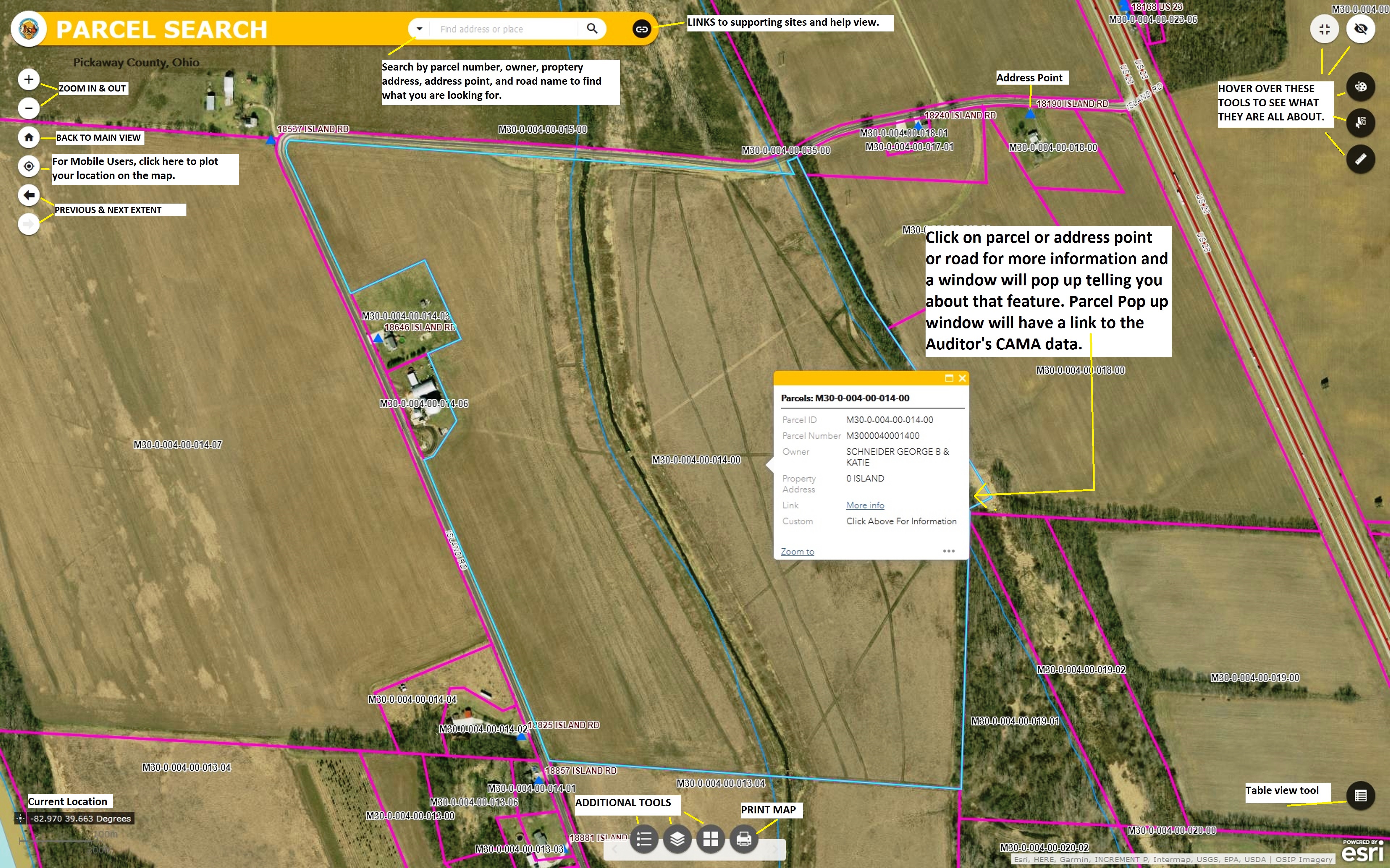
OLD Basic Parcel Search - NEW Basic Parcel Search
Advance One-Stop Parcel Search
Parcel and School District Map – NEW School District Map
Flood Map – Parcel & Address Search – NEW FEMA Flood Map
OLD Soils & Wetland Map – NEW Soils & Wetland Map
OLD Where do I Vote Map – NEW Where do I Vote Map
Economic Development – Pickaway County, OH
Information on ArcGIS Online
Electrical Service Area Outage Information for
Pickaway County
South
Central Power Company – Outage Map
AES Ohio
– Outage Map
AEP-Ohio
– Outage Map
DOWNLOADS
Note: GIS software is required to view
Shapefiles.
A comparison of GIS software can
be found here.
ArcGIS Explorer Free Products
ArcGIS Earth Free Product
Google Earth Page
QGIS Open-Source Page
GRASS
GIS
IF YOU
DOWNLOAD THESE FILES YOU AGREE TO
THE TERMS OF
PICKAWAY COUNTY DISCLAIMER.
SHAPEFILE
DOWNLOADS:
(FOR
SPECIFIC DATA REQUESTS OR MAPS CONTACT THE GIS OFFICE - Email.)
There
may be processing fees for the request.
These files
are in *.zip format and require a program to extract the files.
Such programs
for Windows are: WinZip, Zipeg,
or 7-Zip.
Click on
either of these links to download.
If you
are interested in 1-foot or 2-foot contours for Pickaway County,
please email the GIS Dept for access.
Please See Pickaway Co Disclaimer
Click on the name below
for the GIS shapefile:
- Corporation Boundaries (Nov. 2025)
- Township/County
Boundaries (Sept. 2019)
- Address, Address
Markers & Landmarks -- Metadata (Apr 2026)
- Roads -- Metadata
(Apr. 2026)
- Road Intersections (Apr 2026)
- School
Districts (Nov. 2020)
- Pickaway ESN (Apr. 2025)
- Voting Precinct Information (Sept 2025)
- Pickaway
Co Parcels (Mar 2026)
- Pickaway
2017 Aerial (ECW Format) (Mar 2018)
- Pickaway
2020 Aerial (ECW Format) (Aug. 2020)
- Pickaway 2024
Aerial Download Site (ECW Format) (July. 2024)
- City
of Circleville Wards (July 2019)
- FEMA
DFIRM Information
- NWI Wetlands
- USGS
Contours-Pickaway County Area (Dec 2019)
- Point
Information
- ODOT OCCS
Pickaway Data
- Pickaway County GIS Open Data Site
IF YOU DOWNLOAD THESE FILES YOU AGREE TO
THE TERMS OF PICKAWAY COUNTY DISCLAIMER.
PICKAWAY COUNTY AUDITOR’S
CAMA DATABASE
CAMA Database Download
(Apr. 2026 - 2025 Tax Rate Data)
Zipped file size: 22 MB
For questions concerning the information within the as is
CAMA Database Download,
please contact the Pickaway
County Auditor's Office.
Or general questions, contact this office.
Pickaway
Co. PIN Reference Table
Note: To view
the CAMA Database, you will need Microsoft Access or
an Open Source option to view the
files – OpenOffice or LibreOffice
Access to OGRIP LIDAR information for Ohio - Data
OGRIP 3D Elevation Program - DATA
OSIP 3 2019 Pickaway County 6-inch Imagery
(Information Link & Data Download Site)
6IN MrSID RGB 20x - 2019 (11.7 GB)
6IN MrSID RGB 100x - 2019 (2.3 GB)
OSIP 2 2013 Pickaway County
1-Ft MrSID RGB 20x - 2013
(2.9 GB)
1-Ft MrSID RGB 100x - 2013 (539 MB)
OSIP 1 2008 Pickaway County
1-Ft MrSID RGB - 2008 (1.9
GB)
1-Ft MrSID CIR 2007 - (370 MB)
LIDAR - 2007 (3.1 GB)
ESRI RASTER DEM Tiles - 2007 (3.8 GB)
ESRI RASTER DEM Mosaic - 2007 (3.6 GB)
General
Reference Maps for Pickaway County in PDF Format
Click on
the links below to access the maps.
- GENERAL MAP & Map 2
- PICKAWAY COUNTY 2024 ATLAS BOOK
- SCHOOL DISTRICTS MAPS - Size: 8x11, 11x17 & 44x36
- COUNTY VOTING PRECINCTS – Size: 11x17 & 24x36
- CIRCLEVILLE VOTING PRECINCTS – Size: 11x17 & 24x36
- COMMERCIAL POINT VOTING PRECINCTS – Size: 11x17
- ASHVILLE & SOUTH BLOOMFIELD PRECINCTS – Size 11x17
- VOTING PRECINCTS MAPBOOKS – COUNTY & CIRCLEVILLE
- CIRCLEVILLE WARD MAPS – Size: 8x11 & 24x36
- PICKAWAY CO ESN MAPS – Size: 8x11,
11x17
& 24x36
- LARGE GENERAL MAP 44X36,
- Map 2, Map 3, Map 4, Map 5 & Map
6
- GENERAL COUNTY MAP 11X17
- GENERAL COUNTY MAP 8X11
- COUNTY ECONOMIC & TAX INCENTIVE MAP
- TOWNSHIP MAP
- USGS REFERENCE GRID COUNTY MAP
- COUNTY SECTION MAP & VMS
Map 2
Map
3 Map 4 & Map 5
- MAIN ROUTES MAP
- GENERAL RAILROAD MAP
- GENERAL FEMA FIRM FLOOD MAP
- MAIN STREAMS MAP & Ditch Map
- SMALL USGS CONTOUR MAP & Map 2
- SHADED ELEVATION MAP – Size: 8x11,
11x17, 24x36 & 36x44
- CIRCEVILLE PUMPKIN SHOW GIS Dept Maps: 1, 2, & 3
- Pumpkin Show Area Google
Earth Download (kmz layer)
|
